Product Updates
May 4, 2026
Reality capture, on Autopilot
Teleport turns a flight plan and a drone into a navigable, photoreal 3D capture of an entire neighborhood. The drone flies itself. The cloud reconstructs it. You pick the spot.
Jobin James

Teleport turns a flight plan and a drone into a navigable, photoreal 3D capture of an entire neighborhood. The drone flies itself. The cloud reconstructs it. You pick the spot.
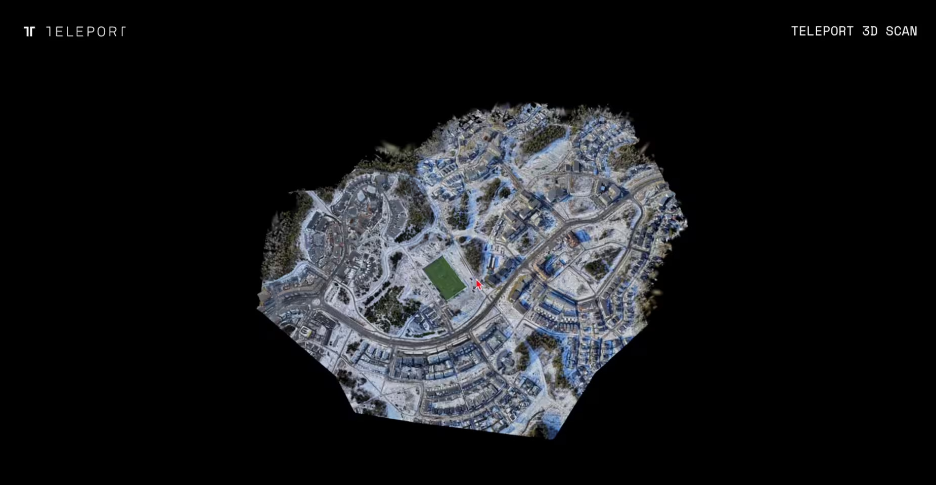
This is Vuores, a neighborhood in Tampere, Finland. You can walk through it in your browser, right now. Every building, every street, every tree.
To make it, someone drew a rectangle on a map. The drone took off, flew the pattern on its own, and landed. The images uploaded to Teleport. A few hours later, this capture was ready to share.
That's the whole process. There's no skilled piloting in the middle. There's no GPU farm in someone's basement. There's no specialist tuning parameters at 2 AM.
Gaussian splatting at this scale isn't unprecedented. Skilled operators with workstations and time can produce captures like this on the desktop. People do.
What's new is that none of the hard parts require an expert anymore.
You're a supervisor at every step, not an operator.
A single capture now supports up to 10,000 images at 5K resolution, producing captures with up to 100 million splats. In real terms: a 100-acre construction site, a kilometer of coastline, an entire residential neighborhood.
Using this pipeline, our beta customers are flying tens of thousands of flights per month, and have captured over 20 billion square meters of real-world environments to date.
Cloud apps like Luma, Polycam, and Kiri are easy and fast, but capped at hundreds to a couple of thousand images. Built for objects and small spaces. They don't operate at km-scale.
Desktop software like Postshot, Reality Capture, and Lichtfeld Studio can handle large captures if you've got the hardware and the patience. They put the work back on you.
Drone mapping platforms like DroneDeploy and Pix4D are starting to add Gaussian splat visualization on top of their core orthomosaic and mesh workflows. DroneDeploy's beta caps at 1,000 images per capture and is view-only inside their platform.
Teleport's large area capture sits in the gap none of those reach: site-scale fidelity, photoreal Gaussian splat output, end-to-end automation from images to a 3D capture, and a pipeline you can build on.
The bigger comparison is to traditional geospatial platforms like Esri and Bentley. Those tools are powerful but expensive, slow to deploy, and require specialist operators. Teleport delivers site-scale 3D output at a fraction of the cost, with the whole pipeline running automatically.
Most large-scale 3D imagery of the world today updates on the order of years, and even then it's rarely more than flat aerial photography. With a drone and Teleport, the same area can now be captured and reconstructed in hours or days, at a fidelity that lets you actually explore the space rather than look down at it from above.
Teleport's large area capture is optimised for workflows like:
Most of these use cases have been technically possible with traditional photogrammetry for years. Each capture was a project: budget approval, specialist operator, weeks of processing, single-purpose output.
What changes with Teleport is automation. When the whole pipeline runs itself, capturing a site stops being a one-off project and becomes a regular update.
For sensitive deployments, these same capabilities are coming to Teleport Secure, our on-premise appliance for defence and air-gapped enterprise environments.
Once a place exists as a navigable 3D capture, you can do things with it that weren't possible before.
To explore that, we built a paragliding simulator on top of a Teleport reconstruction, flying through real terrain that can be re-captured and updated whenever you want. It's a small demo, but it makes a bigger point: the capture isn't the destination, it's a building block. Real estate walkthroughs, construction previews, training environments, games. The pipeline doesn't care what you do with the output.
That's why we expose the same pipeline through our API. Upload images programmatically, kick off reconstruction jobs, retrieve finished captures, embed them in your own product. If your customers need photoreal navigable 3D, you can ship that capability without building a single piece of reconstruction infrastructure yourself.
If you have a drone and a site you want to capture, you can get started today.
Teleport is available as pay-as-you-go for individual operators, with enterprise plans for larger deployments and the on-premise Teleport Secure appliance for sensitive environments.
If you're building a product that needs 3D capture: book a demo or read the API docs.